

The Arctic Ocean
The Arctic Ocean viewed both from a European and North American perspective.
The Arctic Ocean Lue lisää (Kuvallisen nosto)The maps can be freely used provided the sources are credited.
The Arctic Ocean viewed both from a European and North American perspective.
The Arctic Ocean Lue lisää (Kuvallisen nosto)
The Arctic is defined using political, biological and physical criteria.
Definitions of the Arctic Region Lue lisää (Kuvallisen nosto)
Administrative Areas: Arctic states, counties and other administrative regions with capitals.
Administrative Areas Lue lisää (Kuvallisen nosto)
Around four million people live in the Arctic Regions, this map shows the major cities.
Population Centres Lue lisää (Kuvallisen nosto)
The five bioclimate subzones which categorize regions based on temperature, vegetation, and growing season conditions.
Bioclimatic Subzones Lue lisää (Kuvallisen nosto)
The extent of sea ice varies significantly yearly, this map compares the years 2015 and 2025.
Sea ice extent Lue lisää (Kuvallisen nosto)
Permafrost is soil or underwater sediment which continuously remains below zero celisus for at least two years; the oldest permafrost has been continuously frozen for around 700,000 years.
Permafrost Lue lisää (Kuvallisen nosto)
Between forty and ninety languages are spoken in the Arctic.
Arctic Language Branches Lue lisää (Kuvallisen nosto)
Arctic Council member states and observers.
Arctic Council Lue lisää (Kuvallisen nosto)
The regions which are considered belonging to the Arctic in the Nordics
Nordic Arctic Regions Lue lisää (Kuvallisen nosto)
Information on the indigenous peoples who’s organizations are the members of the Arctic Council Permanent Participants.
Facts on Indigenous Peoples Lue lisää (Kuvallisen nosto)
Map based on the data on endangered languages by UNESCO publication.
Northern Languages in Danger Lue lisää (Kuvallisen nosto)
Bathymetric map of the Arctic Ocean and possibly opening sea routes.
Bathymetric Map Lue lisää (Kuvallisen nosto)
Exclusive economic zones in the Arctic Region.
Exclusive Economic Zones Lue lisää (Kuvallisen nosto)Possibly opening seaways when the Arctic Sea ice extents gets smaller
Arctic Seaways Lue lisää (Kuvallisen nosto)

Up-to-date information on the ore prospecting activities in the northern parts of Finland, Norway and Sweden.
Ore prospecting in Northern Europe Lue lisää (Kuvallisen nosto)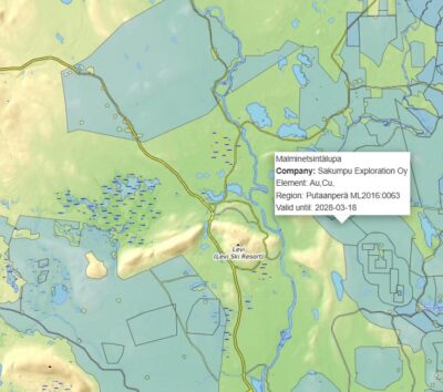
On the map, you can compare the number of ore prospecting activities in 2022 and 2026.
Ore prospecting in Lapland Lue lisää (Kuvallisen nosto)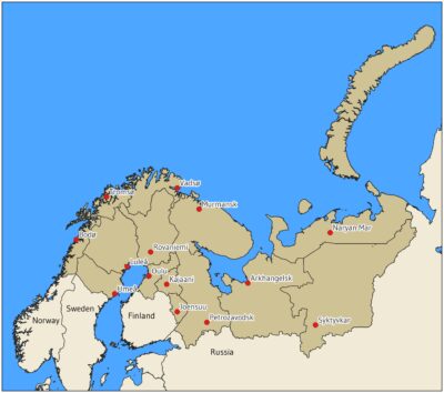
The extent of the interregional and governmental area of cooperation at 2022.
The Barents Region Lue lisää (Kuvallisen nosto)